Road Stream Crossing Site TW009
Tawas River Watershed, Silver Creek
Monument Rd
Wilber Twp,
Iosco County
Information collected by:
Site Location
GPS Coordinates: 44.374603
, -83.602525
T23N
R07E
Sec 21
Owned by Federal
Fish Passability 0
Perch Height: 0.4 ft.
Total Erosion: 0.7321 tons/year
5.6 Upstream Miles
Severity: Severe
Year Inventoried: 2012
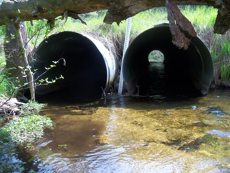
Inlet
Crossing Information
Type of Crossing: culvert(s)
Number of Structures: 2
Structure Shape: Round
Inlet Type: Projecting
Outlet Type: Freefall onto Riprap
Structure Material: Metal
Structure Substrate: None
General Conditions: Fair
Multiple Culverts/Spans | ||||
Culvert/Span | Width | Length | Height | Material |
1 |
4 ft. |
53 ft. |
4 ft. |
Metal |
2 |
4 ft. |
53 ft. |
4 ft. |
Metal |
Structure Interior: corrugated
Dimensions of Structure: Length 53 ft.
, Width 4 ft.
, Height 4 ft.
Perch Height: 0.4 ft.
Structure Inlet
Water Depth: 1.3 ft.
Embedded Depth of Structure: 0 ft.
Water Velocity*: 1.6 ft./sec.
Structure Outlet
Water Depth: 1.1 ft.
Embedded Depth of Structure: 0 ft.
Water Velocity*: 4.9 ft./sec.
*Water Velocities were measured 0.5 ft. below Surface
(with Meter)
Stream Information
Stream Flow: Less than Bankfull
Scour Pool: Length 21 ft.
, Width 15.5 ft.
, Depth 3 ft.
Upstream Pond: Length 0 ft.
, Width 0 ft.
, Depth 0 ft.
Riffle Information
Water Depth: 0.5 ft.
Bankfull Width: 55 ft.
Wetted Width: 14 ft.
Water Velocity: 1.9 ft./sec.
(Measured with Meter)
Dominant Substrate: Sand
Road Information
Paved
County Road
Road Condition: Good
Road Width at Culvert: 23 ft.
Location of Low Point: Other
Runoff Path: Ditch
Embankments
Upstream
Fill Depth: 1.5 ft.
Slope: More than 1:2
Downstream
Fill Depth: 2 ft.
Slope: More than 1:2
Approaches
Left Approach
Length: 700 ft.
Slope: 1% to 5%
Vegetation: Heavy
LS Factor: 0.535
Erosion: 0.2847 tons/year
Right Approach
Length: 1000 ft.
Slope: 1% to 5%
Vegetation: Heavy
LS Factor: 0.57
Erosion: 0.4334 tons/year
Erosion Information
Total Erosion at Crossing: 0.7321 tons/year
Extent of Erosion: Minor
Location of Erosion | Erosion Dimensions | Eroded Material | Material Eroded | Total Erosion | ||
facing downstream | Length | Width | Depth | Reaching Stream? | (tons/year) | |
Left Upstream Embankment |
5 ft. |
4 ft. |
2.8 ft. |
no |
Gravelly Loam |
0.014 |
Summary Information
Fish Passability 0
5.6 Upstream Miles
Fish Passage is an area of concern for this site.
Outlet is perched with a very high water velocity that can prohibit fish from moving upstream
A future visit to this site is recommended. Fish passage issues
�