Road Stream Crossing Site CRW_037
Cedar River Watershed, Tributary to Middle Branch Cedar River
Forest Rd
Franklin Twp,
Clare County
Information collected by:
Site Location
GPS Coordinates: 44.0906
, -84.6261
T19N
R3W
Sec 25
Owned by Private
Fish Passability 0.5
Structure is NOT Perched
Total Erosion: 0.1752 tons/year
Severity: Moderate
Year Inventoried: 2018
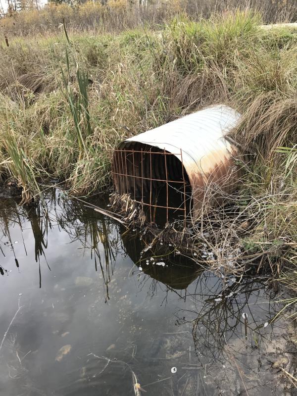
Inlet
Outlet
Crossing Information
Type of Crossing: culvert(s)
Number of Structures: 1
Structure Shape: Round
Inlet Type: Projecting
Outlet Type: At Stream Grade
Structure Material: Metal
Structure Substrate: None
General Conditions: Good
Structure Interior: corrugated
Dimensions of Structure: Length 40 ft.
, Width 3 ft.
, Height 3 ft.
Percentage Plugged:
Inlet: 0%
Outlet: 0%
In Pipe: 0%
Percentage Crushed:
Inlet: 0%
Outlet: 0%
In Pipe: 0%
Structure is NOT Perched
Structure Inlet
Water Depth: 0.5 ft.
Embedded Depth of Structure: 0 ft.
Water Velocity*: 0 ft./sec.
Structure Outlet
Water Depth: 1.1 ft.
Embedded Depth of Structure: 0 ft.
Water Velocity*: 0 ft./sec.
*Water Velocities were measured at the Surface
(with Float Test)
Additional Comments
Lat; 44-05.436 Long: 84-37.566'
Stream Information
Stream Flow: None
Scour Pool: Length 45 ft.
, Width 120 ft.
, Depth 1.5 ft.
Upstream Pond: Length 120 ft.
, Width 50 ft.
, Depth 2 ft.
Riffle Information
Water Depth: 0 ft.
Bankfull Width: 0 ft.
Wetted Width: 0 ft.
Water Velocity: 0 ft./sec.
(Measured with Float Test)
Dominant Substrate: Organics
Road Information
Gravel
County Road
Road Condition: Good
Road Width at Culvert: 20 ft.
Location of Low Point: At Stream
Runoff Path: Ditch
Embankments
Upstream
Fill Depth: 1.5 ft.
Slope: 1:2
Downstream
Fill Depth: 2 ft.
Slope: 1:2
Approaches
Left Approach
Length: 270 ft.
Slope: Less Than 1%
Vegetation: Heavy
LS Factor: 0.05
Erosion: 0.0744 tons/year
Right Approach
Length: 366 ft.
Slope: Less Than 1%
Vegetation: Heavy
LS Factor: 0.05
Erosion: 0.1008 tons/year
Erosion Information
Total Erosion at Crossing: 0.1752 tons/year
Summary Information
Fish Passability 0.5
�