Road Stream Crossing Site S339
Boardman River Watershed, Miller Creek
Railroad
Garfield Twp,
Grand Traverse County
Information collected by:
GPS Coordinates: 44.72332
, -85.62397
T27N
R11W
Sec 22
Adjacent Land Owned by State
Perch Height: 0.67 ft.
Severity: Severe
Site Location
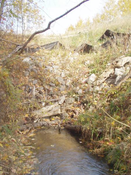
Inlet
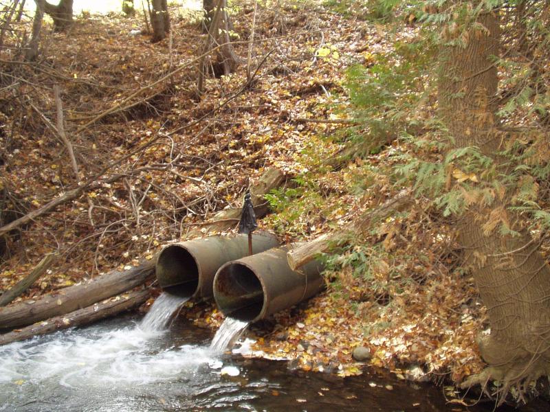
Outlet
Road Approach - Left
Road Approach - Right
Crossing Information
Existing Drainage Control? no
Any Failings? no
Type of Crossing: culvert(s)
(twin culvert)
Is this crossing constricted? yes
Are there adjacent wetlands? yes
Approaches
Left Approach
Right Approach
Culvert Information
Shape: round
Diameter: 2 ft diameter ft.
Material: galvanized
Condition :poor
Flow: fish passage problem
Perch Height: 0.67 ft.
Embankments
Upstream
Fill Depth: 20 ft.
Embankment Slope: 1:1 slope
Downstream
Fill Depth: 20 ft.
Embankment Slope: 1:1 slope
Stream Information
Upstream
Stream Width: 8 ft.
Stream Depth: 6 in.
Stream Current: moderate
Stream Substrate: sand,gravel
Downstream
Stream Width: 15 ft.
Stream Depth: 2 in.
Stream Current: moderate
Stream Substrate: gravel
Erosion Information
Conditions
Is there Streambank erosion beside the crossing? yes
Is there embankment erosion? yes
Is there erosion at the culvert outlet? yes
Is there erosion at the shoulder and/or ditch? no
Is there pooling at the outlet? yes
Is there sand over the crossing? no
Extent of Erosion: severe
Cause of Erosion: inadequate culverts, debris jam at inlet
Recommended Treatments
Action Recommended? yes
Add pavement? no
Add paved raised edge? no
Increase fill? no
Replace culvert(s)? no
Dimensions of replacement: open bottom structure, 8 ft wide
Extend culvert(s)? no
Comments: Massive plunge pool.
Only one culvert inlet is visible.
Serious debris pile at inlet which is mostly buried.
Culverts are way too small for this creek.
Only one culvert inlet is visible.
Serious debris pile at inlet which is mostly buried.
Culverts are way too small for this creek.
Severity:Severe
This page last updated on 2/9/2022.
�