Small Dam Site AUSD_105
Au Sable River Watershed, Unknown stream
Tributary to Beaver Creek
Crawford County
Information collected by:
GPS Coordinates: 44.52343377
, -84.70661373
T25N
R03W
Sec 32
Access Road: Dort (private drive)
Private Ownership
0.15 Upstream Miles Reconnected
Ranking: 1
Site Location
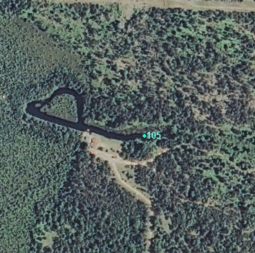
Aerial
Land Use Information
Upstream-Forest
Upstream-Wetland
Downstream-Forest
Downstream-Wetland
Impoundment or Dam Use Information
Unknown
Structural Information
Barrier Type
Earthen Berm
Undersized Culvert
Other Barrier Types:
Driveway
Construction Materials
Earth
Wood
Other Construction Materials:
Bridge
Other Site Features
Vehicle Access
Other Site Features:
Overwash
Upstream Conditions
Widening
Deepening
Wetland Flooding
Is there evidence of erosion?
Upstream
At Structure
Overflow / Breach
Gullies
Downstream
Can bankfull width upstream of Impoundment be determined? no
Direct Stream Measurements
Stream
Widest Impoundment Width (ft): 100
Impoundment Length (ft): 300
Width After Plunge Pool (ft): 1
Depth After Plunge Pool (ft): 20
Spillway
Width (ft): 2
Length (ft): 20
Structure Characteristics
Height of Head (ft): 0.5
Other Pertinent Information
Physical Condition Ranking: 1
Reason/Justification: Shoddy bridge and dirt road
Dominant substrates UPSTREAM: muck
Dominant substrates DOWNSTREAM: sand
Dam has ability to regulate water level? no
Is the dam being actively managed? no
Is another dam or road crossing visible up or down stream? no
Are there any invasive species easily identified? no
This page last updated on 7/6/2022.
�