Small Dam Site AUSD_129
Au Sable River Watershed
Tributary to Au Sable River
Oscoda County
Information collected by:
GPS Coordinates: 44.68032587
, -84.20448559
T26N
R02E
Sec 04
Access Road: Cherry Creek
Private Ownership
0.14 Upstream Miles Reconnected
Ranking: 4
Site Location
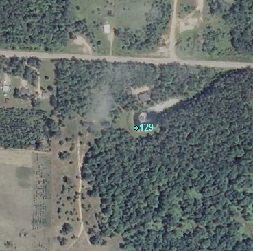
Aerial
Land Use Information
Upstream-Forest
Upstream-Wetland
Downstream-Forest
Downstream-Wetland
Impoundment or Dam Use Information
Recreation
Wildlife Pond
Structural Information
Barrier Type
Earthen Berm
Other Barrier Types:
Culvert
Construction Materials
Metal
Other Construction Materials:
Culvert dam
Other Site Features
Upstream Conditions
Widening
Deepening
Change to Lake / Pond
Is there evidence of erosion?
Upstream
At Structure
Downstream
Can bankfull width upstream of Impoundment be determined? no
Direct Stream Measurements
Stream
Widest Impoundment Width (ft): 100
Impoundment Length (ft): 300
Area of Impoundment (sf): 2 acres
Width After Plunge Pool (ft): 6
Spillway
Width (ft): 2
Length (ft): 50
Water Velocity (ft/sec): 0
Structure Characteristics
Height of Head (ft): 2
Freeboard Available (ft): none-to top of culvert
Other Pertinent Information
Physical Condition Ranking: 4
Dominant substrates UPSTREAM: sand
Dominant substrates DOWNSTREAM: silt
Dam has ability to regulate water level? yes
Is the dam being actively managed? yes
Is another dam or road crossing visible up or down stream? no
Are there any invasive species easily identified? no
This page last updated on 7/6/2022.
�