Small Dam Site AUSD_113
Au Sable River Watershed, East Branch Big Creek
Oscoda County
Information collected by:
GPS Coordinates: 44.81500407
, -84.30165781
T28N
R01E
Sec 15
Access Road: County Rd 489
Private Ownership
0.17 Upstream Miles Reconnected
Ranking: 1
Site Location
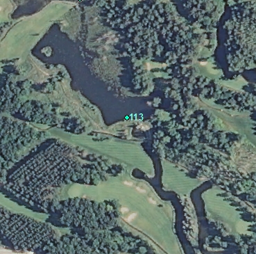
Aerial
Land Use Information
Other:
Golf course
Other:
Golf course
Impoundment or Dam Use Information
Impoundment/Dam Other:
Golf course pond
Structural Information
Barrier Type
Other Barrier Types:
Riser
Construction Materials
Wood
Metal
Other Construction Materials:
(wood stop boards, metal culverts)
Other Site Features
Vehicle Access
Upstream Conditions
Change to Lake / Pond
Is there evidence of erosion?
Upstream
At Structure
Gullies
Bare Soil
Bank Failure
Undercut Banks
Downstream
Can bankfull width upstream of Impoundment be determined? no
Direct Stream Measurements
Stream
Widest Impoundment Width (ft): 100
Impoundment Length (ft): 900
Area of Impoundment (sf): 5 acres
Widest Width of Plunge Pool (ft): 8
Width After Plunge Pool (ft): 6
Depth After Plunge Pool (ft): 1
Spillway
Width (ft): 3
Length (ft): 40
Water Velocity (ft/sec): N/A
Structure Characteristics
Height of Head (ft): 4
Height of Structure (ft): 6
Freeboard Available (ft): 2
Embankment Length (ft): 5
Other Pertinent Information
Physical Condition Ranking: 1
Reason/Justification: Wash out,smashed culvert,exposed wires
Dominant substrates UPSTREAM: sand/silt
Dominant substrates DOWNSTREAM: sand
Dam has ability to regulate water level? yes
Is the dam being actively managed? yes
Is another dam or road crossing visible up or down stream? no
Are there any invasive species easily identified? no
This page last updated on 7/6/2022.
�